Multivalued Sequence Stratigraphy
Fuzzy Classification of Maximum Flooding Surface
One of the best horizons for stratigraphic correlations commonly identified as the "maximum flooding surface." However, recognizing the maximum flooding surface is complicated by the fact that the surface is classified by 1) ambiguous characteristics, 2) unspecified degree of importance for individual characteristics in defining the surface, 3) different identification techniques for various datasets, and 4) various and often conflicting genetic interpretations attributed to descriptive definitions.
The fuzzy logic methods of "fuzzy classifier design" and "fuzzy inference systems" have been used to address these problems of classification and genetic significance. Fuzzy methods quantify subjective data so that geologic observations are repeatable, accept context dependency, and effectively integrate much of the qualitative and quantitative data available. These qualities are used to 1) quantify sedimentary characteristics through fuzzy classifier design to reduce subjective identification and to facilitate repeated recognition of the maximum flooding surface in rock descriptions and to 2) develop a fuzzy inference system to elucidate the genetic significance of the surface. The fuzzy inference system argues that the time of maximum sediment starvation and maximum flooding are discrete events. The surface of maximum starvation, as recognized in outcrop, is recorded as a synchronous horizon, whereas the maximum flooding event is complicated by the interplay of rates of sediment accumulation and accommodation space.
Fuzzy MFS Classifier
As an approach to reduce subjective identification and facilitate repeated recognition
of the maximum flooding surface, a fuzzy classifier has been developed for use in
outcrop or core description. This Windows-based program allows input of both qualitative
concepts and quantitative data to define a surface. The fuzzy classifier uses eight
predetermined criteria for recognizing the surface from sedimentary and stratigraphic
descriptions including relative abundance peaks of microfossils, stable isotope signatures,
bed thickness, gamma-ray signature, organic and glauconite content, evidence of hardground,
burrowing concentration, faunal concentration, and increase in water depth.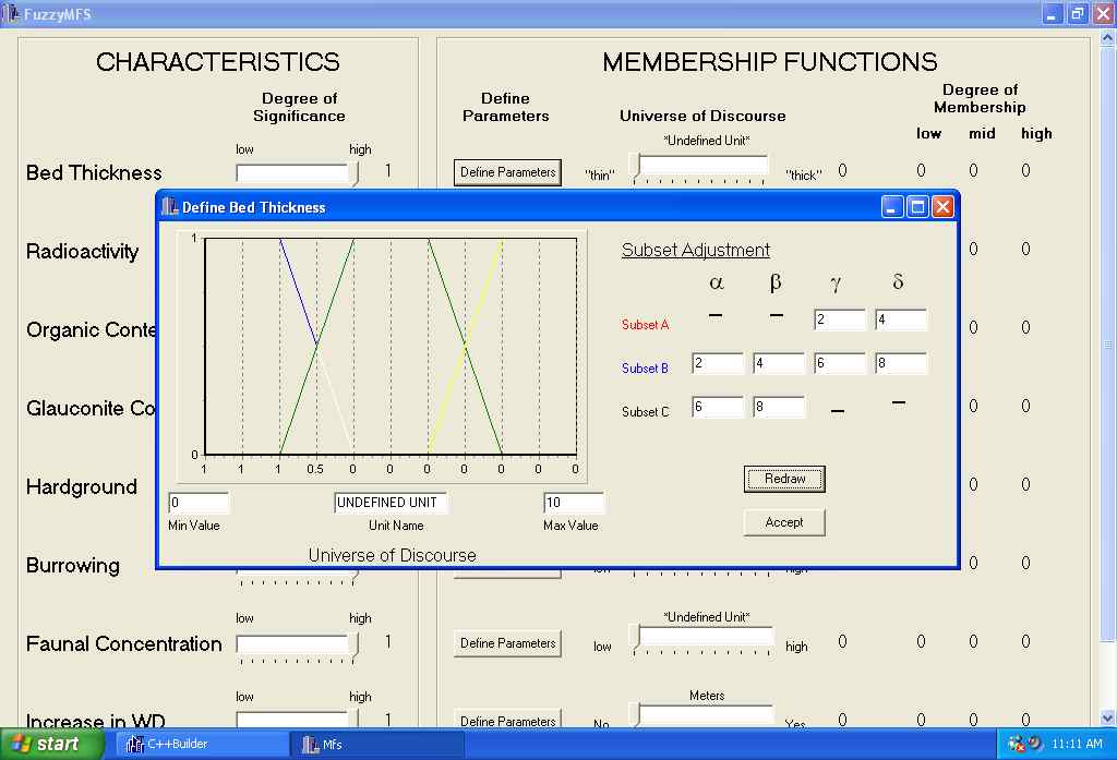
The user first predefines the degree of significance that each criterion has on their
recognition of the surface. This may range from 0 (no significance) to 1 (very significant).
To return to the example of bed thickness, in some cases this parameter may be considered
of "low significance" because it appears that certain depositional processes maintain
near constant bed thickness through a sequence. Parameters for each criterion and subsets are then defined. For example, for the criterion
faunal concentration, the user defines the boundaries for the overlapping classes
"low," "moderate," and "high" faunal concentration. Once parameters are defined, individual
field observations are characterized in terms of degrees of truth through membership
functions. Truth values for each characteristic are then combined and weighted by
degrees of significance to produce an aggregate membership function that is used to
then define if the bed is a maximum flooding surface.
Fuzzy Inference System
Our workgroup has developed a three-dimensional (3D) numerical stratigraphic model
to simulate the development of microbial reefs on a Jurassic carbonate platform using
fuzzy logic modeling methods. The results of this model were recently published in
the Journal of Sedimentary Research (July 2003). The flexibility of the model allows
for the examination of a large number of variables. The relative importance of local
environmental conditions and global changes on the frequency of reef development are
examined relative to the temporal and spatial constraints from Upper Jurassic (Oxfordian)
Smackover reef datasets from two Alabama oil fields. The fuzzy model simulates the
deposition of reefs and carbonate facies by integrating local and global variables.
Local-scale factors include basement relief, sea-level change, climate, latitude,
water energy, water depth, background sedimentation rate, and substrate conditions.
Regional and global-scale changes include relative sea-level change, climate, and
latitude.
The model confirms preexisting theories that background sedimentation rate, water
energy, substrate, relative sea-level change, and climate influenced the development
of Jurassic reefs. Additionally, the model determines the degree of control each variable
has on 'IF,' 'WHERE,' and 'WHEN' reefs develop. The variables that control 'IF' reefs
develop are the global parameters of climate and amplitude of sea-level change. The
model specifies that the variables that influence the lateral distribution of reefs
(or 'WHERE' reefs occur) are substrate, water energy, and background sedimentation
rate. The model also indicates a strong correlation between 'WHEN' reefs develop and
the rate of sea-level rise. In all simulations, reefs initially develop in conjunction
with the greatest rate of sea-level rise (i.e., the inflection point on the sea-level
curve) and reach peak development before the time of deepest water.