Geographic Information System (GIS)

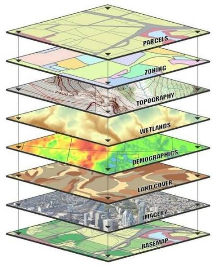
GIS is a rapidly growing technology used to "capture, store, manipulate, analyze, and display all types of spatially referenced geographic information about what is where on the earth's surface and how they relate to each other" (ESRI 2002). Open to ALL undergraduate students. The GIS undergraduate certificate at Wichita State University is essential to undergraduate students anticipating working with its wide-ranging applications, including the capturing of data from your field of study into "layered spatial contexts" known as "Story Maps". No matter your field of study, GIS is definitely for you!


GIS Students collaborating

To add the GIS certificate to your plan of study:

  • Log into the myWSU portal, find the Student Tools box (center of the page) and click "Change my Major/Minor."
  • Click continue (this will show your current major and minor).
  • Click continue, then click on "Add a certificate" and choose your certificate program. Click continue and submit request.


STEM MODELING

Story Maps

Telling the "Tale"

ArcGIS StoryMaps is an ArcGIS-based application that allows users to narrate remarkable stories with conventional maps that enlighten and inspire others.

Most people debated that traditional journal articles can sometimes be hard to read. They are often wordier than a presentation and can be viewed as more boring. Conversely, StoryMaps can grab the reader's attention with its various features. In building your StoryMaps, you can use different media types such as pictures, videos, and maps. Story Maps is better than the traditional journal articles by taking students to that place with pictures and updated interactive 2D and 3D maps. Additionally, interacting with a more creative report will make it better and more fun for the students/users.

Therefore, the GIS certification advisory board believes that introducing the ArcGIS StoryMaps to the students provides students' narrative a stronger sense of spatial relationships or visual appeal and credibility to their ideas, but it is also a timely manner.

Who can take GIS?

Program Coordinator

Dr. Peer H. Moore-Jansen
Professor and Department Chair 
Department of Anthropology

Wichita State University
1845 Fairmount

Wichita, KS 67260-0052 

(316) 978-7059 

pmojan@wichita.edu 

Facebook